Project: Connectivity conservation prioritization of forests and wetlands in the St. Lawrence Lowlands
Year: 2018-2019
Focus Area: Ecosystem Services (Habitat Connectivity)
Year: 2018-2019
Focus Area: Ecosystem Services (Habitat Connectivity)
Project Overview
To ensure the sustainability of biodiversity and ecosystem services in fragmented landscapes, current conservation plans increasingly focus on protecting connected habitat networks. Connectivity within habitat networks means that animals can move from patch to patch, accessing distributed resources throughout the network. In the long term, many animals will need to move across habitat networks to shift in their ranges in response to climate change.
Conserving connected habitat networks is particularly important in highly fragmented and rapidly changing landscapes such as the St. Lawrence Lowlands in Quebec, Canada. Remnant forest habitat in the Lowlands represents just 30% of the total area and is distributed across relatively small patches embedded within agricultural and urban areas. This landscape is undergoing rapid expansion of low-density urban areas, which continues to erode the existing habitat networks and threaten biodiversity persistence.
We identified connectivity conservation priorities for the St. Lawrence Lowlands based on habitat preferences and dispersal abilities of five focal species: Northern short-tailed shrew, American marten, Red-backed salamander, Wood frog, and Black bear. We mapped conservation priorities among the remaining forests and wetlands based on their contribution to connectivity at multiple spatial scales (Rayfield, Pelletier, Dumitru, Cardille et al., 2016) and for multiple species (Albert, Rayfield, Dumitru, and Gonzalez, 2017). We also mapped conservation priorities among potential movement corridors (linkages) that connect existing protected areas in the Lowlands.
The resulting maps of connectivity conservation priorities represent optimal trade-offs among the different habitat suitability and connectivity criteria of all focal species. These mapped priorities are intended to guide integrated landscape management decisions whereby the interconnectedness of habitat fragments and the surrounding landscape is factored into decision-making.
Additional Information
Interactive map of habitat connectivity in the St. Lawrence Lowlands
Tools used: Circuitscape, igraph R package, grainscape R package, Zonation, Linkage Mapper
Albert, C. H., Rayfield, B., Dumitru, M., and Gonzalez, A. 2017. Applying network theory to prioritize multispecies habitat networks that are robust to climate and land‐use change. Conservation Biology. doi:10.1111/cobi.12943
Pelletier, D., Clark, M., Anderson, M. G., Rayfield, B., Wulder, M. A., and Cardille, J. A. 2014. Applying circuit theory for corridor expansion and management at regional scales: tiling, pinch points, and omnidirectional connectivity. PLoS One. doi:10.1371/journal.pone.0084135
Rayfield, B., Pelletier, D., Dumitru, M., Cardille, J. A., and Gonzalez, A. 2016. Multipurpose habitat networks for short‐range and long‐range connectivity: a new method combining graph and circuit connectivity. Methods in Ecology and Evolution. doi:10.1111/2041-210X.12470
Photo credit Northern short-tailed shrew: Gilles Gonthier - some rights reserved (CC BY)

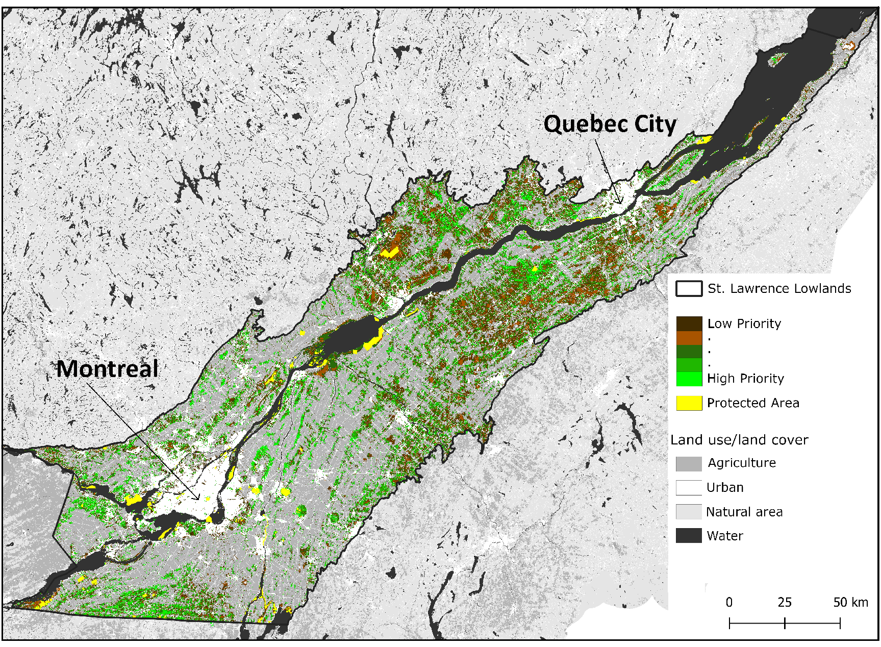
Connectivity conservation priorities for forests and wetlands within the St. Lawrence Lowlands in Quebec, Canada (30 156 km2). Priority areas were identified at a 30m resolution based on habitat suitability and connectivity analyses derived from current land use and land cover for the five focal species (125,688,228 cells).

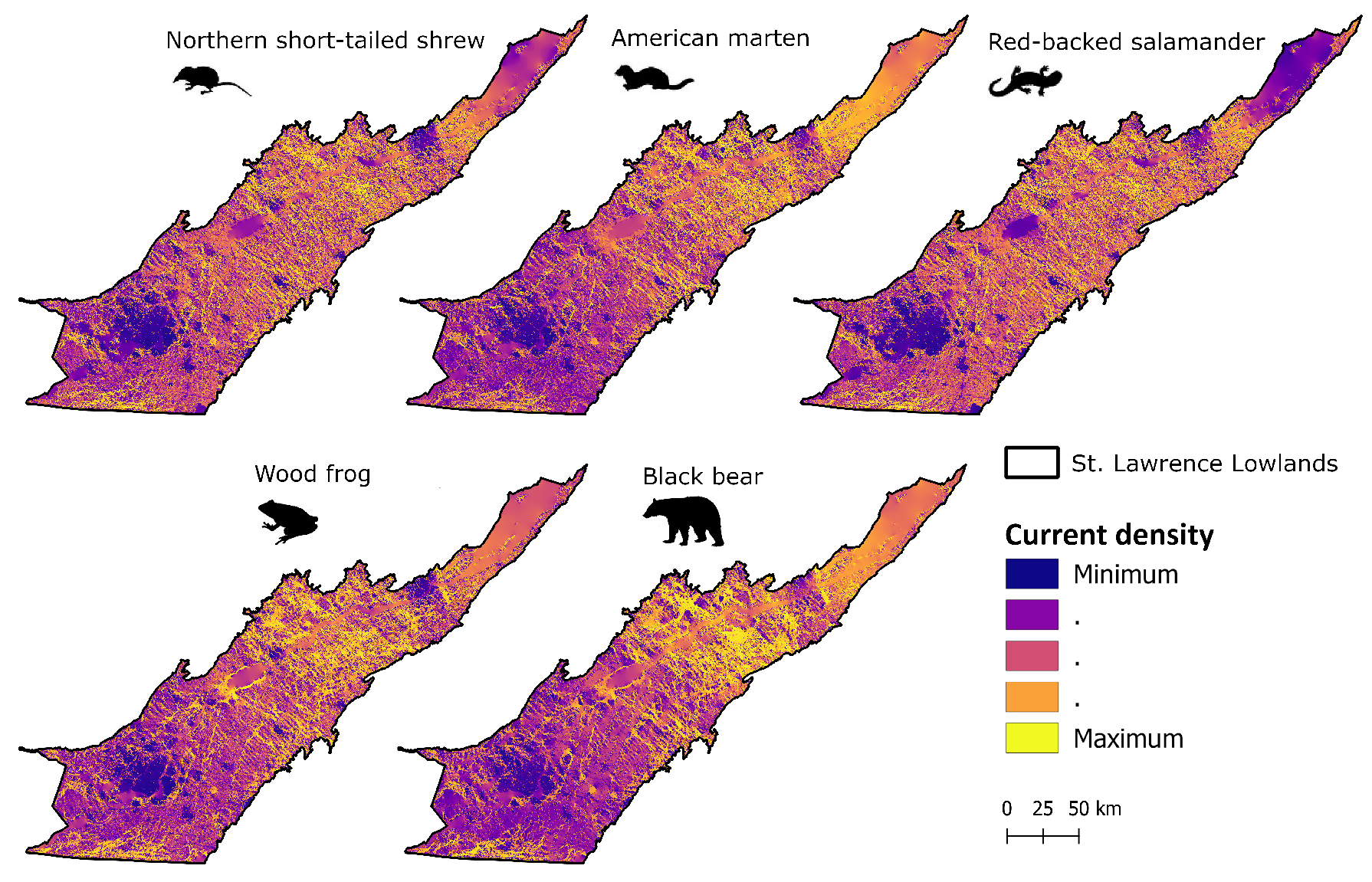
Connectivity maps for each focal species within the St. Lawrence Lowlands in Quebec, Canada. Connectivity was calculated using a circuit model, based on an estimate of the density of electric current propagating through species-specific resistance surfaces (Pelletier et al., 2014).
Project:
Conservation prioritization of natural habitats in the St. Lawrence Lowlands based on their importance for ecological connectivity
Year: 2018-2019
Focus Area: Ecosystem Services (Habitat Connectivity)
Project Overview
To ensure the sustainability of biodiversity and ecosystem services in fragmented landscapes, current conservation plans increasingly focus on protecting connected habitat networks. Connectivity within habitat networks means that animals can move from patch to patch, accessing distributed resources throughout the network. In the long term, many animals will need to move across habitat networks to shift in their ranges in response to climate change.
Conserving connected habitat networks is particularly important in highly fragmented and rapidly changing landscapes such as the St. Lawrence Lowlands in Quebec, Canada. Remnant forest habitat in the Lowlands represents just 30% of the total area and is distributed across relatively small patches embedded within agricultural and urban areas. This landscape is undergoing rapid expansion of low-density urban areas, which continues to erode the existing habitat networks and threaten biodiversity persistence.
We identified connectivity conservation priorities for the St. Lawrence Lowlands based on habitat preferences and dispersal abilities of five focal species: Northern short-tailed shrew, American marten, Red-backed salamander, Wood frog, and Black bear. We mapped conservation priorities among the remaining forests and wetlands based on their contribution to connectivity at multiple spatial scales (Rayfield, Pelletier, Dumitru, Cardille et al., 2016) and for multiple species (Albert, Rayfield, Dumitru, and Gonzalez, 2017). We also mapped conservation priorities among potential movement corridors (linkages) that connect existing protected areas in the Lowlands.
The resulting maps of connectivity conservation priorities represent optimal trade-offs among the different habitat suitability and connectivity criteria of all focal species. These mapped priorities are intended to guide integrated landscape management decisions whereby the interconnectedness of habitat fragments and the surrounding landscape is factored into decision-making.

Connectivity conservation priorities for forests and wetlands within the St. Lawrence Lowlands in Quebec, Canada (30 156 km2). Priority areas were identified at a 30m resolution based on habitat suitability and connectivity analyses derived from current land use and land cover for the five focal species (125,688,228 cells).

Connectivity maps for each focal species within the St. Lawrence Lowlands in Quebec, Canada. Connectivity was calculated using a circuit model, based on an estimate of the density of electric current propagating through species-specific resistance surfaces (Pelletier et al., 2014).
Additional Information
Interactive map of habitat connectivity in the St. Lawrence Lowlands
Tools used: Circuitscape, igraph R package, grainscape R package, Zonation, Linkage Mapper
Albert, C. H., Rayfield, B., Dumitru, M., and Gonzalez, A. 2017. Applying network theory to prioritize multispecies habitat networks that are robust to climate and land‐use change. Conservation Biology. doi:10.1111/cobi.12943
Pelletier, D., Clark, M., Anderson, M. G., Rayfield, B., Wulder, M. A., and Cardille, J. A. 2014. Applying circuit theory for corridor expansion and management at regional scales: tiling, pinch points, and omnidirectional connectivity. PLoS One. doi:10.1371/journal.pone.0084135
Rayfield, B., Pelletier, D., Dumitru, M., Cardille, J. A., and Gonzalez, A. 2016. Multipurpose habitat networks for short‐range and long‐range connectivity: a new method combining graph and circuit connectivity. Methods in Ecology and Evolution. doi:10.1111/2041-210X.12470
